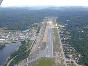
After many years of development, Mont-Tremblant finally is accessible by air
at less than 35 minutes form the Mont-Tremblant International Station.
The military airport of La Rouge (previously La Macaza) has been transformed in a civilian airport
of international class.
Critics are unanimous to describe the quality of services and the convenience
for travellers staying at Mont-Tremblant.
With this airport, Mont-Tremblant opens the door to a prestigious clientele
and is proving again it's international vocation.
You will find hereafter the technical caracteristics of the Mont-Tremblant International Airport.
A shuttle service to Mont-Tremblant is offered during the winter season.
La-Rouge-Mont-Tremblant International, QC
Aerodrome Information
Location identifier: CYFJ


 After many years of development, Mont-Tremblant finally is accessible by air
at less than 35 minutes form the Mont-Tremblant International Station.
The military airport of La Rouge (previously La Macaza) has been transformed in a civilian airport
of international class.
After many years of development, Mont-Tremblant finally is accessible by air
at less than 35 minutes form the Mont-Tremblant International Station.
The military airport of La Rouge (previously La Macaza) has been transformed in a civilian airport
of international class.
 With this airport, Mont-Tremblant opens the door to a prestigious clientele
and is proving again it's international vocation.
With this airport, Mont-Tremblant opens the door to a prestigious clientele
and is proving again it's international vocation.